
It's a trail that doesn't go through any towns aside from passing by a few ski resorts, requires a fair level of experience with navigation, and there are no facilities along the track aside from a few mountain huts within the Kosckiusko National Park. You need to be self sufficient for shelter and food, and find your water in streams and rivers. You need to arrange food drops along the way if doing the whole thing, which means hiding it in the bush by the track in vermin proof containers if you don't have a support team. It's quite an undertaking.
Having cut my teeth walking the very untechnical Bibbulman Track, where logistics are a lot simpler to arrange, I bought myself the updated guidebook written by Chapman and Siseman, and happened to share this information on Facebook. My brother mentioned that he too was interested in the walk, and over Christmas a plan was hatched. I was coming over east in March for a university reunion so we decided to tackle a section of the track prior to my get together. We invited fellow walker friends to join us and soon it was a reality.
In the end there were three of us. My brother Matt, myself, and Iain, whom I'd met on the Bibbulman Track last year. Iain and Matt both live in or near Canberra so I was the only one who needed to travel far to get there.
We began on Friday when Iain's wife Sandra drove us out to Kiandra via Cooma and Adaminaby, stopping at The Ringing Rock before donning our backpacks and heading off.

It was an easy walk across grassy plains, fording the occasional stream to our evening's campsite at Witze's Hut. We saw no other walkers, but did meet a group of four on horseback who looked straight out of the Man from Snowy River.


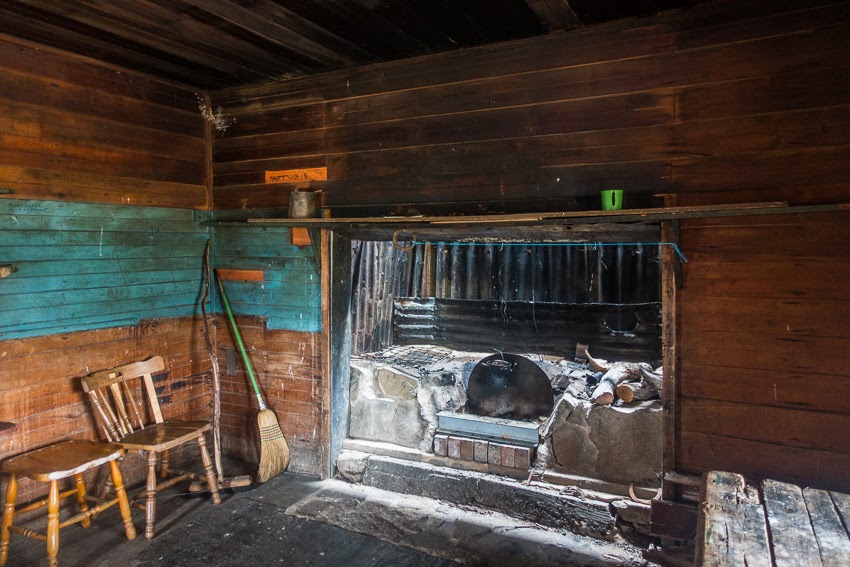
At Witze's hut we pitched our tents and checked out the hut. The Kosciusko National Park has hundreds of old cattlemen's huts throughout the high country, many of which have been restored, and are for public use. The biggest risk to the huts is fire, either externally by bushfires, or through carelessness by hut occupants.


We chose to have a campfire outside and chat for a while before succumbing to our air mattresses.


The morning dawned clear and we were soon packed and on our way. We walked through a few more valleys, then detoured to visit Haine's Hut, perched above the Murrumbidgee River and a popular spot for fly fishermen. We then returned to the track, forded a stream, lunched at the Murrumbidgee River, then climbed up onto a large plain and headed towards the Port Philip Trail and our planned campsite at Ghost Gully.


However feet were feeling sore, and there was another hut just off the route that we decided to visit, so instead of continuing on to a busy campsite we turned off up an old fire trail and had an idyllic evening camped outside Miller's Hut.


Day 3 again dawned clear and we were soon away and off down the Bally creek to rejoin the track. At Ghost Gully we met Matt's friends Bug and Ben on their way back from camping at Hainsworth Hut, the next hut we also visited.


Both Matt and I were suffering from blisters, so we made our way slowly to Blue Waterholes whilst Iain detoured to Old Curango Homestead before joining us at our campsite later. We planned to stay two nights here, in order to explore the caves and restored Cooleman Homestead the following day. And give our feet a chance to recover.


It rained overnight and we woke to a misty morn, but it cleared to yet another glorious day. Matt and I donned our Crocs and the three of us went exploring through the caves at Blue Waterholes. The area is riddled with limestone caves and two are easily accessible along a walk through the Nichol Gorge.


After lunch we walked up the road to Cooleman Homestead. This is a collection of buildings that have been rebuilt and serve as a reminder of how pastoralists lived in the high country. The walls are made of wood slabs, the ceilings and walls insulated with horse hair, and the walls lined with old newspapers. The earliest we found dated back to 1931.


A refreshing swim at Blue Waterholes topped off the day, and we were early to bed after it began to rain that evening. It rained heavily overnight, but it was dry in the morning, so we managed to pack up and get going before the rain began again. The rain fell in earnest after an hour of walking so we put on the wet weather gear, then turned in to visit Pocket Hut. And lo and behold, 2 more groups of walkers turned up in the rain as well. The only walkers we had seen, and they all turned up at the same hut in the rain!


The rain got worse so we decided to lunch there, which ended up being a great decision, because after an hour or so the rain eased somewhat.


So with full bellies we headed back out in lighter rain for a further couple of hours to Oldfields Hut.


Oldfields is a three room hut set a few hundred metres above the Goodradigbee River, which is a mere stream at this point. It has been restored to some of its old glory, complete with uneven slab verandah, and resident possum! We unpacked all our wet gear and strung it up to dry under cover, then spied a group of nine horsemen approaching. This group of country farmers all had packhorses and were on a five day trek through the mountains. One of the old guys really knew the history of the mountains and the old cattlemen and was a delight to listen to. Unfortunately they decided to move on to their own campsite for the night. Perhaps they didn't want to share their whisky!


We had originally planned to head further to Murrays Gap, but with more heavy rain forecast we decided to stay put within the comfort of the hut, complete with a nice warm fire in the fireplace. As a result we were able to pack all our stuff up nice and dry in the morning.


After crossing the Goodradigbee, the track began to climb up to Murrays Gap. We could see how damp and wet it was, so were glad we'd made the decision to stay back at the hut, but we did find some nice campsites up there.


At Murrays Gap we entered the ACT, and the Cotter River Water Catchment Area, for which we had to apply for a camping permit to the Bimberi Wilderness from Namadgi National Park Office. It's free, and can be done by email, so not much hassle at all. You need a separate permit to have a campfire.


From Murrays Gap the track heads downhill to the Cotter River, via a ranger's hut with a very annoying gate to get through.

We had lunch at Cotter River and then it was climbing again to Cotter Gap, and our campsite for the night. We found a lovely spot near a stream, and set up our tents along with the Ponchotarp Hilton: 2 rain poncho tarps clipped together. This afforded us lots of room to sit and cook out of the rain, which fortunately didn't start until we'd set up camp, and only rained for an hour at most. We watched a beautiful sunset.


Next day it was a short walk to the top of the Gap and then down to the Orroral River valley. Here we met numerous groups of Outward Bound school kids, which reminded me of doing the same thing when I was at school. We had lunch at the river and then began the most painfully long and steep climb of the trip. So many false summits.....


From the top of Orroral Ridge Road it was a steep descent to Honeysuckle Creek Campsite. We were the only ones there, so we commandeered the group camp area with it's large covered eating area and covered fireplace. Again we had already pitched our tents before the late afternoon rain began to fall. And then we met a trekker heading the other way, who had just started out that afternoon on his trek all the way to Walhalla in Victoria. We chatted for a while but he was keen to head on to his first fuel and food drop at the top of Orroral Ridge, despite us offering him our excess fuel. Off he headed in to the rain, whilst we sat around the fire and chatted on our final night. And yes, we began planning the next trip!
Our final day involved a gentle climb up to Booroomba Rocks carpark. Both Matt and I had climbed up to the Rocks many times in our youth, as well as more recently on one of my Christmas visits, so we forwent that detour and began the long descent to Tharwa.
I sent the boys off ahead, as I was now in serious pain, because I had stupidly burst the two blisters I had developed under each of my big toes. Neither blister had been painful, but they were huge, and pushing my nails up and out. The day before I'd got the knife out and cut both of them open. And then today we had a 850m descent! From the balls of my feet backwards I felt great, but that inch of me north felt like hell on earth! I plodded along slowly, and very painfully.


At the turnoff to Mt Tennant the boys had left their packs to detour to the summit. I had no intention of adding to the amount of metres of descent for the day, so I lunched there, then left a very clear message in the track that I had passed them and was heading on to Tharwa. Apparently they missed this!

The descent got steep, but a lot of it was over rock steps, which are less painful to descend as your foot is flat rather than inclined, so less pressure against the poor sore toes. And the views were glorious.


And then it's a short walk across the Naas Road to the Namadgi National Park Office. Off came the shoes, on went the mobile phone, and the wait for the boys began. Thank goodness because they didn't know I'd passed them! A few texts later, an hour or so wait in the sun with the feet up, and the boys arrived. Then Sandra turned up with the cold beers!
We had done it.
Next March we'll do the next section: Kiandra to Dead Horse Gap!