Time to head north. First stop Dunedin where my camera, which had been in for repairs since the LCD monitor stopped working whilst tramping in the Takitimus in February, was at last ready for pickup. Then unfortunately back all the way to Glenorchy to pick up my boots which I had accidentally left at Kinloch Lodge in the drying cupboard after walking the Greenstone Caples. Luckily I had a bed in Wanaka so no biggie...
Then at last I headed over the Lindis Pass and into Canterbury, with the plan to go tramping in Arthur's Pass. But the long range weather forecast was looking bleak, ie stormy and rainy and probably snowy.......
As usual the north east coast was in a rain shadow, so off to Kaikoura I went.
I hadn't been to Kaikoura since the devastating earthquake in 2016 that isolated the town for months. The coastal highway had taken a full year to reopen following the massive uplift in the earth's crust that damaged so much infrastructure. It was now over two years, and the effect it had had on the economy of a town hugely reliant on tourism is still very evident. It felt a lot quieter, but then again, May is hardly high season....
My plan was to climb up Mt Fyffe, in the coastal Kaikoura Range, then pop down into the valleys on the other side of the mountain and walk back out. Although there were tracks, these too had been damaged by the earthquake, so I wasn't quite sure what was in store.
It began to rain soon after I arrived in Kaikoura, and it was a cold blustery night. In the morning it was cold, and on the hills it had snowed. The first snow of the season!
From the Mt Fyffe carpark the track follows a 4WD track the entire way to the hut. The weather was sunny and clear, so I dropped the backpack at the hut and headed up to the summit, which takes a further hour if you take your time. The fresh snow everywhere made beautiful patterns where the wind-drifts crossed the path. Wilding pine are a real menace up there, but they sure look pretty with a coat of snow!
Just as I got to the summit I realised I had been beaten there by a couple of Australian ladies who had arrived by helicopter! I'd heard the machine noise but didn't twig that they were flying well healed punters to the summit and providing them with a glass of bubbly with their view. They took some photos, skulled their drinks and then they jumped in their machine and were gone.
Silence but for the wind. Glorious views in all directions. Including along the razor ridge to the Kowhai Saddle.
I decided that with the new snow and the potential for a slide to be fatal, I wouldn't attempt the walk along the ridgeline to the saddle as I don't own crampons. Instead I would take a steep route down to Kowhai Valley from near the hut and then walk upstream to Kowhai Hut. This would mean I could stay below the snowline and still walk a loop, just a different loop....
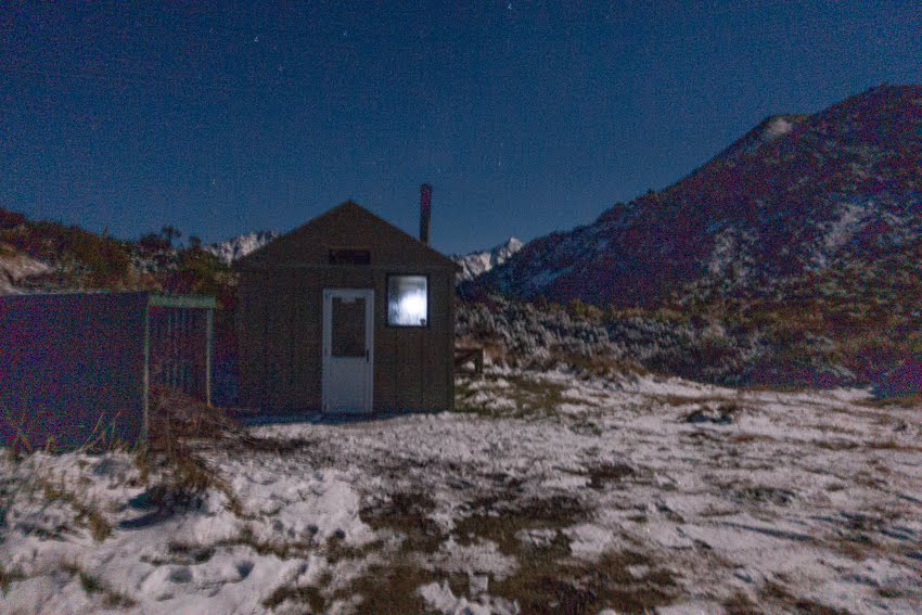
Back at the hut I was joined by another group of walkers, overseas backpackers, and a local young man who drove up in his 4WD, ostensibly to do some surveying for his job, but mostly to have a meetup with one of the girls who was tramping with her two friends. It was a beautiful sunset, made even more so by the rising full moon, and with a clear night, I tried for some star shots.
The next morning, after watching a spectacular sunrise, they all piled in to his car and drove back down the hill. That left me to continue my tramp in solitude.
The track I was taking is a faint footpad, not well marked, that plunges almost vertically into Kowhai Valley. I was glad I was going down because it would be a killer walking up, but it still required a lot of concentration to keep upright and keep on track. As I reentered the forest lower down the track became more discernible, and soon I had arrived at the river.
From there, there was a fairly good track all the way up river, but I needed to keep an eye out for the best point to cross the river to get to the hut. It's a sweet little six bedder in a clearing up on a river terrace, and that evening I was joined by a father and son who regularly visit the hut and have taken a sort of guardianship over the place. The young boy was celebrating his 8th Birthday, so I joined them eating their huge supply of Tim Tams, introducing the birthday boy to the joy of a Tim Tam Slam!!
The next morning the boys left before me, packing out any rubbish left behind by other hut users (not me), and I followed about a half hour after them. I never caught up to them all day, but was very glad they were in front of me, because the track below where I joined the river yesterday disappeared or was poorly marked for large sections. The river must be crossed multiple times (I'd hazard a guess it was more than 10) in order to bypass cliffs and bluffs, and there are only a few small rock scrambles hardly worth mentioning. I mean if an 8 year old boy can do it.... At times the only way I knew where to go was to follow wet footprints. Thanks guys.
At last the river widened to a large gravelly expanse and I followed dry braids until the track markers started again and the final walk through some teatree spat me out at the carpark.
I stayed another night in Kaikoura and then headed north to Marlborough, visiting Ward Beach enroute. The 2016 earthquake caused an uplift in the seabed all along the coastline, up to 5.5m at Waipapa Bay, but at Wards it exposed round boulders just like those at Moeraki further south. Only no crowds!
By mid afternoon I am in Renwick, visiting my friends Rick and Barb who I met on the Humpridge a year ago. I stayed a couple of nights whilst they helped me plan my next expedition.
It involves a packraft! That's next....
A blog about travel, my globe trotting obsession and the home and garden I love, so what if there's a little conflict between the two...
Monday, May 20, 2019
Saturday, May 11, 2019
An all weather circuit, with some detours
There are so many multi-day tramps to do around Glenorchy, including the Rees Dart and the Routeburn, but I decided to do the Greenstone Caples. Firstly, it was a true loop track that started and ended at the same carpark, secondly, it could be walked all year round. It was now late Autumn when the weather gets quite unpredictable. It could snow any time, making exposed alpine tramps treacherous. Thirdly, there was the opportunity to visit a few little huts up some side creeks and to tick them off my increasing tally on the Hutbaggers website.
Hutbaggers is a bit of fun. The website provides a list, with photos and maps, of all the huts in NZ, including old huts that have since been removed. There are thousands of huts, some private, but the majority publicly accessible, all over New Zealand. They are the product of past ventures in the wild spots of NZ, from deer culling and forestry huts, to mountaineering and tramping, and even for glacial research. Most are now managed and/or maintained by either DOC, various alpine or tramping clubs, hunting groups, individuals or community groups like Permolat and Permolat Southland. New huts are also being built as new tracks are developed, or old huts require replacement. I'd managed to visit 87 so far, and was keen to get to 100 before returning to Wanaka for the winter ski season.
The walk begins at the end of the road where the Greenstone River enters Lake Wakatipu. It's a lovely drive down the western side of the Lake from Kinloch and through a few remnant woodlands to Greenstone carpark. After a quick lunch I hauled on the backpack and headed off up the river, past the swing bridge and continued up the Caples River. It was an easy amble, mostly along the river flats checking out the river for packrafting opportunities, and meeting a few hunters carrying their beasts out on their backs.
It was a pretty cruisy 3 hours to Mid Caples Hut, situated on a terrace above the river, just after crossing a bridge over a spectacular small gorge. I was joined that evening by a chap on an angling trip, but otherwise the quite spacious hut was empty.
The next morning I continued further up river, to just above Upper Caples Hut, a former DOC hut now owned by the Deerstalker Association. There I crossed a swing bridge and headed up Kay Creek to a hut just below the treeline. Getting to the hut involved crossing a fairly substantial stream, but although knee deep it wasn't at all dangerous. The waterfalls coming off the bluffs higher up were nothing short of spectacular.
Kay Creek Hut is pretty basic, with a rather damp earth floor and simple beech branches used to keep the structure standing. But it had a fireplace, and bunkbeds with mattresses, so it wasn't hard to make it warm and comfortable.
The next morning I headed back down the Creek to the Caples, stopping in at Upper Caples Hut just so I could tick it off the list, then continued up river.
The route takes you up onto McKellar Saddle, a lovely tussock and tarn filled basin with views over Lake McKellar to the Livingstone Ranges. The track down to the lake is quite steep, and then it's a bit of a muddy scramble along the lake shore to McKellar Hut.
It's a beautiful clear night and the hut is one of those where the firebox is in the communal area, so the bunk rooms are unheated. But it's not too cold overnight, and in the morning it begins to rain.
It rains all day. The track follows the Greenstone River, which is a much wider valley than the Caples, and there are lots of cattle grazing, making some of the going rather muddy. By lunchtime, despite wearing my wet weather gear, I am rather damp and rather cold, so I take shelter on the verandah of the private Steele Creek Lodge for lunch, and decide not to head up Steele Creek to the hut, but continue downstream to Greenstone Hut. Whilst the more heavily used tracks often have bridges over the bigger waterways, smaller tracks often require stream crossings, and when it's raining you can expect the streams to be much higher than usual. So best to keep to the main track...
At Greenstone Hut there are already numerous others, who have already got the fire going so I am able to strip off my wet gear and get warm pretty quickly. It's quite surprising how quickly one can get cold, even on the valley floor. And I was even wearing my polypro gloves!!
The next morning it's a 3.5 hour stroll down the valley back to the car. The rain from yesterday has cleared, but the track is a quagmire caused by cattle also using the track. There are a number of gorges in the lower Greenstone, but they aren't visible from the track, so I'm unsure whether they are suitable for paddling. I have lunch at the shelter, and then drive back up the road to Kinloch Lodge, and enjoy a welcome soak in that hot tub.
MMMM....
Hutbaggers is a bit of fun. The website provides a list, with photos and maps, of all the huts in NZ, including old huts that have since been removed. There are thousands of huts, some private, but the majority publicly accessible, all over New Zealand. They are the product of past ventures in the wild spots of NZ, from deer culling and forestry huts, to mountaineering and tramping, and even for glacial research. Most are now managed and/or maintained by either DOC, various alpine or tramping clubs, hunting groups, individuals or community groups like Permolat and Permolat Southland. New huts are also being built as new tracks are developed, or old huts require replacement. I'd managed to visit 87 so far, and was keen to get to 100 before returning to Wanaka for the winter ski season.
The walk begins at the end of the road where the Greenstone River enters Lake Wakatipu. It's a lovely drive down the western side of the Lake from Kinloch and through a few remnant woodlands to Greenstone carpark. After a quick lunch I hauled on the backpack and headed off up the river, past the swing bridge and continued up the Caples River. It was an easy amble, mostly along the river flats checking out the river for packrafting opportunities, and meeting a few hunters carrying their beasts out on their backs.
It was a pretty cruisy 3 hours to Mid Caples Hut, situated on a terrace above the river, just after crossing a bridge over a spectacular small gorge. I was joined that evening by a chap on an angling trip, but otherwise the quite spacious hut was empty.
The next morning I continued further up river, to just above Upper Caples Hut, a former DOC hut now owned by the Deerstalker Association. There I crossed a swing bridge and headed up Kay Creek to a hut just below the treeline. Getting to the hut involved crossing a fairly substantial stream, but although knee deep it wasn't at all dangerous. The waterfalls coming off the bluffs higher up were nothing short of spectacular.
Kay Creek Hut is pretty basic, with a rather damp earth floor and simple beech branches used to keep the structure standing. But it had a fireplace, and bunkbeds with mattresses, so it wasn't hard to make it warm and comfortable.
The next morning I headed back down the Creek to the Caples, stopping in at Upper Caples Hut just so I could tick it off the list, then continued up river.
The route takes you up onto McKellar Saddle, a lovely tussock and tarn filled basin with views over Lake McKellar to the Livingstone Ranges. The track down to the lake is quite steep, and then it's a bit of a muddy scramble along the lake shore to McKellar Hut.
It's a beautiful clear night and the hut is one of those where the firebox is in the communal area, so the bunk rooms are unheated. But it's not too cold overnight, and in the morning it begins to rain.
It rains all day. The track follows the Greenstone River, which is a much wider valley than the Caples, and there are lots of cattle grazing, making some of the going rather muddy. By lunchtime, despite wearing my wet weather gear, I am rather damp and rather cold, so I take shelter on the verandah of the private Steele Creek Lodge for lunch, and decide not to head up Steele Creek to the hut, but continue downstream to Greenstone Hut. Whilst the more heavily used tracks often have bridges over the bigger waterways, smaller tracks often require stream crossings, and when it's raining you can expect the streams to be much higher than usual. So best to keep to the main track...
At Greenstone Hut there are already numerous others, who have already got the fire going so I am able to strip off my wet gear and get warm pretty quickly. It's quite surprising how quickly one can get cold, even on the valley floor. And I was even wearing my polypro gloves!!
The next morning it's a 3.5 hour stroll down the valley back to the car. The rain from yesterday has cleared, but the track is a quagmire caused by cattle also using the track. There are a number of gorges in the lower Greenstone, but they aren't visible from the track, so I'm unsure whether they are suitable for paddling. I have lunch at the shelter, and then drive back up the road to Kinloch Lodge, and enjoy a welcome soak in that hot tub.
MMMM....
Subscribe to:
Posts (Atom)