From Nelson I headed north, through Motueka and up Takaka Hill. Last time I was there, in 2018, was a few months after cyclone Yasi had caused a massive slip cutting Golden Bay off for a few weeks. Incredibly, they are still working on the road over Takaka Hill, and there is still a 15 minute wait at the traffic lights to allow one way traffic through the slip zone.
Once on the hill I went to visit the Ngarau Caves, a commercial tour through one of the many caves in this area. There are Moa bones on display, found in the cave after they must have fallen down one of the thousands of sinkholes in this region.
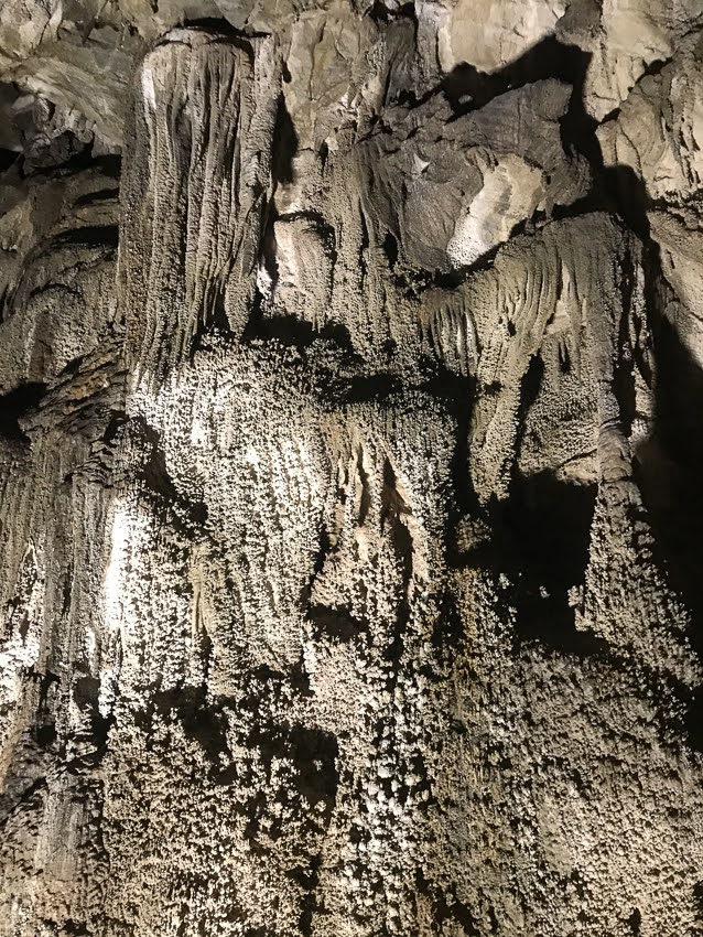


Once I had taken the obligatory selfie with the Moa, it's on down the dirt road to Canaan Downs, to walk in to Harwood Hole, an enormous sinkhole that can be abseiled down into, to explore a massive cave system below. I just went for the wander, my speleological days well behind me....


After camping the night at the DOC campsite, and experiencing my first frost of the year, I went for a day walk in to the Wainui Valley, to visit a hut I hadn't been to when I walked the inland track of the Abel Tasman a few years ago.

In the clearing near the hut is an aviary, used by DOC to house native birds before introducing them back into the wild. No birds there when I visited, but lots of predator trapping evidence.

Once back at the carpark, I drove back to the highway, through Takaka, and out to Wainui, where I camped at a little eco camp called Rata camp. I was the only guest. I chatted to the camp hosts, who gave me some good tips for tramping in the area.
The next morning I went tramping in Abel Tasman National Park. Firstly I went to Taupo Point, taking the low tide route on the way there, which required a little rock scrambling to visit some lovely sea caves. The beaches were stunning.


Once back from Taupo Point I rejoined the Abel Tasman Coastal Track to Whariwharangi Hut and Bay. I hadn't gone this far when I'd walked the loop a few years ago because DOC had closed the beach route through Mutton Cove and Anapai Bay due to cyclone damage. The track was now restored, but I only planned to walk out to Separation Point to see the seal colony, as I didn't have time to walk all the way around to Totaranui and back via Gibbs Hill. Plus it was a hot day, and I knew how diabolical that climb up from Totaranui was!!

Whariwharangi Hut is an old farmhouse, reputed to be be haunted, and has a lot more character than the other Great Walk Huts. I only stopped long enough to use the loo and write in the intentions book. Then off to Separation Point.

Separation Point separates Tasman Bay from Golden Bay, has a small lighthouse, and a bunch of seals lying around on the rocks. It also has a bunch of plastic gannets and a loud speaker broadcasting audio of a gannet colony, in an attempt to attract gannets from Farewell Spit to form a new colony there. So far, this effort has been unsuccessful.


I walked back the same route, and spent a second night at Rata Camp. The next morning I visited the very impressive Wainui Falls.


Next, onwards to Takaka to replenish supplies, then off up north further. With a two to three day weather window and a favourable tide schedule I decided to do the walk out to Kahurangi Lighthouse. And in order to get closer to the start I camped the night at Pakewau. My campsite looked straight out to the sea...

I was up at 6am for an early breakfast and then off down the road to Anatori Rivermouth. It's about 40km long, but it's a winding dirt road that skirts Whanganui Inlet and then weaves past limestone cliffs past small farming hamlets to Anatori River. As I was in a hurry I didn't stop to take photographs.
I arrived at Anatori River at 8:30 am. I had packed the night before so it didn't take me long to get on the road. There were people camped at the river mouth, and I realised belatedly I could have made up some time by camping there too. I had a low tide appointment at Big River for just after 11am.
Once across the Anatori River, which is fordable with a 4WD, I walked around to the beach and began my walk down the coast.
However, up ahead were big cliffs, with waves crashing on the rocks at their base. The tide was not yet low enough to continue along the beach. Just before the cliffs I spied a bach on a terrace in the dunes, and behind it I found a cattle track that climbed steeply up to the ridge above the cliffs. I sidled around on the farmland, staying high on the ridge, until I saw the road further inland. Lucky for me the ridge I was on began to descend, and I found another cattle track which headed down to join the road. I continued along the road to Turimawiwi River, which also required fording.
There are no further roads south of the Turimawiwi, aside from the track to a nearby farm house. Getting supplies to the lighthouse always required overland travel along the beach at low tide, as the coast was too treacherous for boats.
I walked over the dunes back to the beach and began my hurried walk along the coast. It was now 10:15 and I had 2 tidal estuaries to cross. I began to intermittently jog along the hard sand, trying to make up time. I was passed by some people on dirt bikes and quads, also enjoying the opportunity to get down the beach whilst the tide was out.
Crossing the first estuary at Anaweka was easy. It's narrow and only ankle deep near the beach. I continued on, still breaking out into a jog from time to time. I met a couple coming the other way, who informed me that I needed to cross Big River within the estuary, and not at the beach, because the channel was far too deep. Even crossing the estuary was chest deep for them. This was sounding just a little scary...


I powered on and got to Big River about 11:15, probably as close to full low tide as possible. The quad bike crew were on the other side, having crossed in the estuary and I could see that the water was too deep to cross at the beach. This didn't stop me trying anyway, but I retreated pretty quickly once the water got above my waist. Instead I made the long walk in soft mud around the estuary to near where the others were carefully bringing their quad bikes back across. I found some shallower sand spits and managed to make my way across with the water only just getting to hip depth. There was very little current in the estuary so there was no risk of losing my footing. Then I walked back up the other side of the estuary back to the coast line, where I stopped for lunch. I could now relax as all the hard work was done.


I could see other trampers behind me, so I gesticulated wildly, trying to indicate that crossing in the estuary was the best option. It turns out they didn't see me, so they crossed at the river mouth, and got very wet. A couple more trampers even further behind followed their example, and had to swim across!!
The final couple of kilometres was a stress free stroll along the beach and then up to the lighthouse keepers cottage. I met a young chap camping nearby for a week or two, but I was the first one at the cottage for the night. The other two couples straggled in over the next hour or so, and proceeded to empty their wet backpacks and put their gear out to dry. I was the only one to have perfectly dry gear. Apparently the hippie couple returning along the beach hadn't spoken, or even waved at, the others, so they hadn't known to cross in the estuary. They did now!!


I wandered down the beach to see the lighthouse, but the scramble up through the bushes to it looked a bit too challenging to do in Crocs or barefoot, so I made do with some photos and returned before the incoming tide cut me off.


The next day the low tide was at 12:15, so I had a leisurely morning before strolling back to the Big River crossing in bare feet. It was a joy to take my time and enjoy the wild coastal scenery without the stress of making the tide.


I arrived a little before low tide as the water was higher than it had been the day before, but made my way back along the side of the estuary then began crossing, in a somewhat zig zag fashion, retreating when the water level went above my waist to find a shallower sand spit to walk on. It took a little time, but I got across again without any collateral damage, ie wet gear, and then spied one of the other couples trying to cross in the estuary. They couldn't understand my gesticulations, and ended up crossing in a direct line a bit further into the estuary than me. Their route was chest deep, and they were considerably taller than me! I picked the better line.

I stopped for lunch after the second inlet crossing, where the boys caught up with me and we compared notes on our crossings. Then we walked together along the beach until the dunes at Turimawiwi River, where the boys stopped for lunch and I continued on. Once across the river I put my shoes and socks back on for the final 7km along the road back to the Anatori River. I didn't fancy testing the low tide route along the beach again...


At Anatori River I set up camp for the evening, and went for a refreshing swim in the river. I wanted to enjoy the drive back out without worrying about finding somewhere to stay for the night, which is what I did the next morning. It is a very scenic drive, well worth the winding gravel road.


Back on the main drag I had lunch in Collingwood and then booked in to a hostel in Takaka. There was rain forecast for the next few days, and anyway, I had laundry to do...
The weather forecasts worsened, which gave me the opportunity to catch up on my blog posts and edit photographs. But with no improvement for the next 10 days it's time to leave Golden Bay and go find some better weather. Kahurangi I will be back, but I'm not going tramping in the rain with no views thank you very much...